As a project manager, it is important to obtain the right measurements of your project site. Knowing what is on the terrain or on a roof, is an essential decision point in the complex process of a project. To give it a fancy name, you cannot have a “digital twin” if the starting point is not correct.
In the last decade, the affordability of highly advanced sensors has increased drastically, leading to a situation where a wide range of options is available to measure an existing situation. The most important are:
Manual survey with a GNSS RTK receiver
In this solution a surveyor walks in the area of interest and measures each point that he considers important for the survey. He will use a GNSS RTK rover, which is a device that uses satellite signals (e.g. GPS) to determine the exact coordinates down to centimeter-level accuracy. All the points together will be used to determine the terrain in the most accurate way.
Photogrammetry with drone pictures
Drones take normal pictures that are stitched together using a technology called photogrammetry. If you want to “talk the talk” of the drone community, you can call it RGB, which is nothing more than an acronym for Red Green Blue. As you probably know, a pixel in a picture is determined by a Red, Green, and Blue value, so these are just normal pictures. What is quite spectacular, though, is that each picture that the drone takes has a precise geotag with the coordinates of that point. By stitching the pictures together, an algorithm is able to reconstruct the “As-Is” situation on the ground. Sounds complex? No worries, our processing team can literally do this in their sleep.
LIDAR sensor on a drone
You might have heard about LIDAR technology because it is being used in autonomous vehicles and many other applications. It stands for Light Detection and Ranging and works like a radar. The principle behind it is simple: the sensor emits a laser pulse and then waits to receive the return. The time it takes to receive the return can be transformed into distance because each pulse is travelling at the speed of light. The difference with photogrammetry is substantial: each point of the terrain is measured directly, while with photogrammetry the measurement of each point is a result of a complex calculation.
Other
There are other ways to measure a terrain but the above alternatives are the most common ones.
What is the best?
Now comes the one million dollar question: which technology is the best? At Inflights, when we are discussing drone flights with our prospects and clients, we get this question all the time. The answer is not straightforward at all, and invokes some complex trade-offs between the limitations of each technology and, of course, price. The first option, doing the survey manually, has become very expensive compared to the drone solution, especially for large terrains. It is much more productive to fly over a 100 ha terrain than to measure a terrain manually. In this Inflights Whitepaper, we compare the drone solution with the manual surveyor.
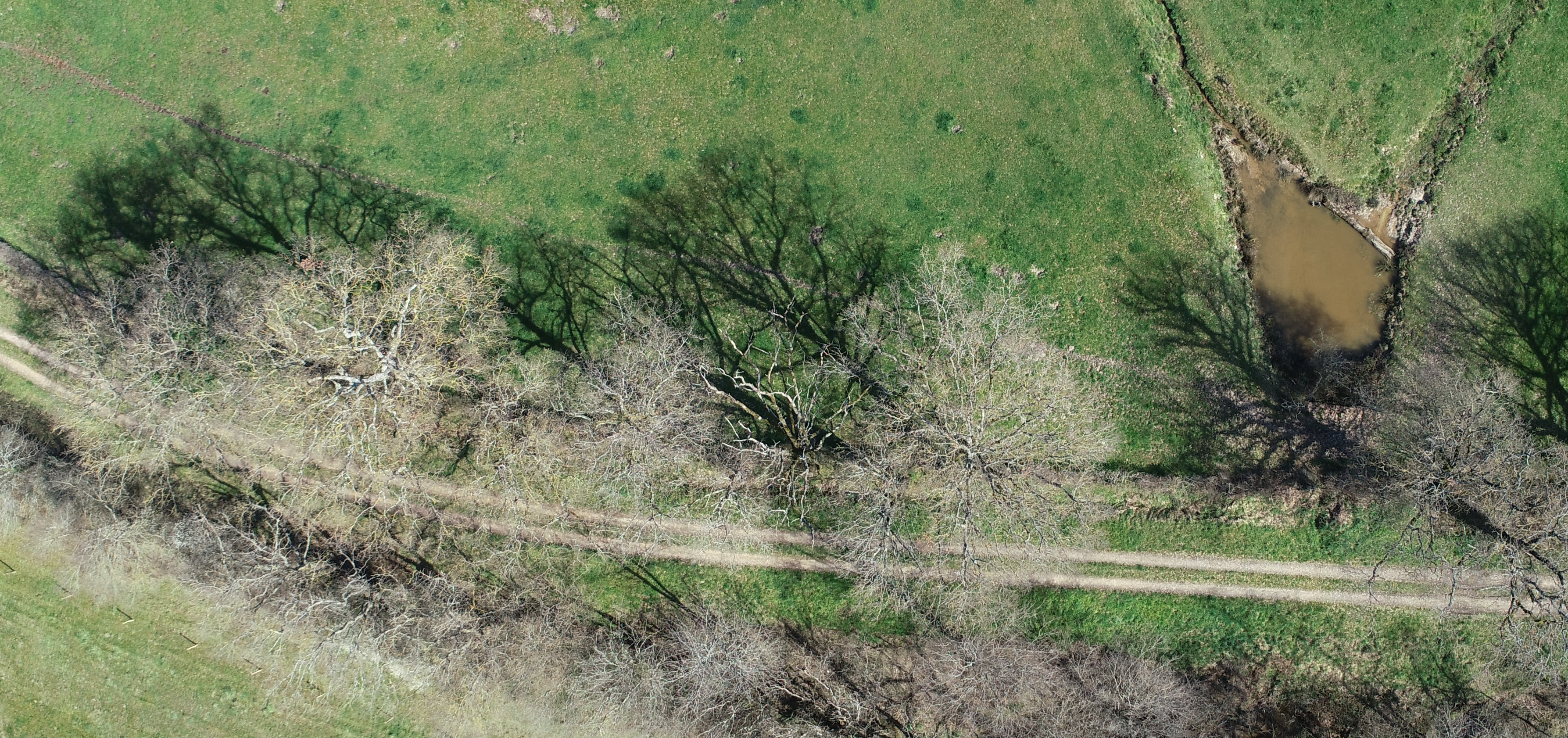
It is all about the vegetation
The most important element that will drive the choice between LIDAR and photogrammetry is the status of the vegetation on the terrain. Vegetation in this context is defined as trees, bushes, high grass, and anything that a project manager will not consider as part of the Digital Terrain Model (DTM). It is crucial to be able to distinguish between the terrain and the vegetation, because you cannot build on vegetation. To again use some fancy wording: the terrain will be captured in a Digital Terrain Model, while the vegetation will be part of the Digital Surface Model (DSM). Almost always the DTM will be the starting point for many projects. The fact that a DTM is needed is the reason for the existence of the LIDAR technology, as you are able to measure the terrain underneath the vegetation. Because LIDAR works with pulses, the chances of penetrating the vegetation to reach a point on the ground are higher. Because photogrammetry is based on visual pictures, you will measure only the elements that you can see from the air. If there are trees, you will measure the top of the trees and not the terrain underneath it. The same goes for dense bushes and high grass. You measure what you can see from the air.
So why not always use LIDAR? It seems like it is the holy grail? So it does seem that LIDAR should be used always, as it seems to be a superior technology. You would indeed think that, but it is not so simple. Many reasons are there to not go for LIDAR.
First, LIDAR is more expensive than photogrammetry, because the technology is complexer and it requires more power to operate, which then requires a heavier drone which is again more expensive. Because it is more expensive, not so many products are designed and produced, which again leads to higher prices. At the same time, there are many affordable photogrammetry drones available, leading to more affordable prices.
Second, LIDAR availability is much more limited because there are simply less of them that are sold. If you have a project in Cameroon, finding a drone pilot that has a LIDAR is not trivial.
Third, you can never be 100% sure you got the terrain. The pulse from the sensor on the drone might find a path through the tree canopy, but it could bounce back on high grass that is under the tree canopy, but 1 meter above the terrain. If you simply assume that in that case you are measuring the terrain, you might be wrong. Increasing the number of returns of the LIDAR signal might improve the chance of reaching the ground, but it will also increase the price.
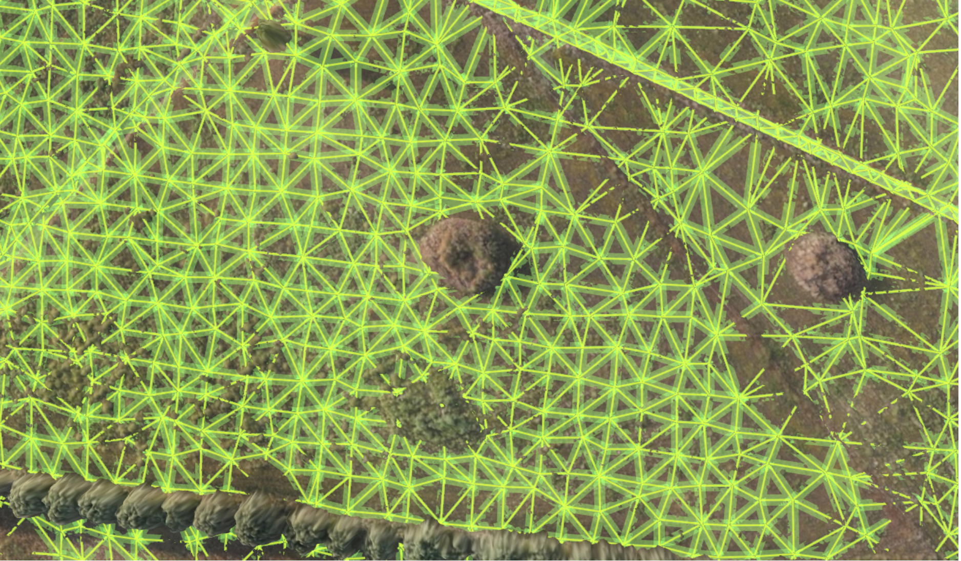
Fourth, is the terrain data under the vegetation really needed? Very often the trees will not be removed as this is ecologically bad and costly. In that case, the tree canopy is important for shadow calculations, but the exact height of the terrain under it might not be important. The Inflights sales team guides our client to make the correct trade-off here. Why pay for information that is not needed? The picture below illustrates how Inflights assesses the terrain using advanced point cloud processing algorithms.
Fifth, the information around the vegetation could be sufficient to develop a correct DTM. With drone technology, it is now possible to obtain centimeter ground resolutions, but this might not always be needed. Let us go back to the era before drones. The Scope of Work (SOW) of a project would require that a land surveyor measures a point every 10m or even every 20m on flat terrain. If you can approximate the terrain under a tree where you only miss 1 m2, this will be more than enough to accurately represent the terrain.
Lastly, we can always go back to the basics. There are situations where the information from a photogrammetry drone is not enough. This is often the case for ditches and trenches, where the vegetation is covering important height differences of the waterways. Here drone photogrammetry can be combined with the measuring of manual points. The Inflights sales team will have a discussion with the client to understand the specific needs for each project to ensure that the most cost effective solution is used.
How does Inflights deal with this?
One of the unique advantages of working with Inflights, is that we have access to virtually all type of sensors in the world. This allows us to choose the right tool for the job, depending on the requirements of each client and each project. In our standard workflow we always set up a meeting with the technical engineering team of our client, to have a good understanding of their expectations. Investing time in this meeting upfront, allows us to manage the expectations well and deliver what we have promised.