Analyze Measure volumesaccurately and quickly
Measure stockpiles and earth works using drone data. Always know your exact quantities.
Analyze
Volume measurements reinvented
Using drone data allows you to measure stockpiles in a completely new way
Higher resolution
The stockpiles are modeled with centimeter resolution, allowing you to achieve a much higher accuracy than traditional methods
Survey grade
Our survey engineers follow strict procedures to ensure the quality of our deliverables are survey-grade.
Zero Hassle
Our experience working with solar has taught us what file types and sizes to use, so that you can import them into your existing workflow.
Accurate
All elements are modeled in the digital twin to a very high degree of accuracy. This way it can be used as the starting point for high precision design.
All obstacles modeled
All relevant obstacles that have an impact on the positioning of solar panel designs are modeled.
Universal Formats
Multiple file format outputs are possible to ensure you are able to integrate the deliverables easily.
Stockpiles Accurate Stock Inventory
We can take an inventory of your stockpiles at any given time. We will calculate the volumes, and you can compare the terrain with earlier states. We not only give you a volume report, but you also get a full overview of the site, all achieved by our photogrammetric solution. Rest assured you will get an accurate estimation of your stock, at unprecedented precision.
Deliverables
A standardized set of products ready to integrate into your existing workflow.
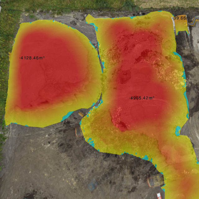
Stockpiles
A report containing the volumes of stockpiles.
Orthomosaic
The area is represented by a photorealistic map. This map is made of rectified photos and synthesized into an accurate high resolution georeferenced image.
How it works
Our global pilot community and central team are ready to help you obtain the drone data for your project
Standardized process
-
Request your quote
- Upload the area to be mapped to the Inflights Platform or select an area on the map.
-
Get an instant price
- Our algorithms will generate the best price for you based on our pricing agreements with our pilot community.
-
Sit back and relax
- We ensure that all legal requirements are met. We keep you updated with all the critical steps in the process and inform you when the final deliverables are ready.
-
Download or View your results online
- View your deliverables online or use our ready-to-use files on your own software to start designing your site.